Showing posts with label hiking. Show all posts

Sunday, July 20, 2008

Days 49&50: Wrong Way Laura

When I got up Saturday morning, it took me a while to get the gumption up to go out and hike. It was going to be an incredibly hot day. I hadn't hiked in 2 weeks, I really sort of wanted to just sleep in. But, I had to get back on track.

I chose an relatively simple hike. It lists as a 4 mile moderate loop on High Mountain in Wayne, NJ. But once again, because of some trail re-routing it is a little longer now, almost 4 and 1/2 miles. Still not bad and there is only one serious up. Well, at least if you do the hike as written and don't take a wrong turn right off the bat...

I should have known it was going to be one of those days. Once I got myself together to head out, Scott asked if I would drop him at the post office since it was so hot out. We got in the car and I started to make a turn, the wrong way on a one way street. I've lived here for 17 years, how could I mess that up? I caught myself and corrected it, and laughed it off saying, "Well, that doesn't bode well for my hike today!" If only I knew then...

I knew generally where I was going and I had the hike directions, so I was halfway to Route 80 before I realized that the hike directions did not include how to get there from Route 80. I pulled over and pulled out a couple of maps, alas, they did not have details of the area, but I got a decent sense of which way to go and was relying on memory to get me the rest of the way there. I knew from 80 I had to get on Rt 23 North. But after that getting over to 504 was going to be luck of the draw. I passed the exit for Alps Road (go ahead and snicker Ed) even though it sounded familiar and headed up to Packanack Road because that also sounded familiar. I cruised through a lovely residential area and realized that while I wasn't on the right road, I was heading in the general direction. I eventually found Ratzer Road which also sounded familiar and turned onto it in the general direction I thought I needed to go. Soon I was at Alps Road again with a sign directing me to Rt. 504. Oops, well, I only went a little way out of my way.

Once I hit 504 I was on the hike directions. I cruised up College Road, but a lot had changed and they didn't have Parking Lot signs like they used to. I also noticed a new lot specifically for High Mountain Park. So I drove right past Parking Lot #6, realized my mistake and had to turn around. When I came back, I decided to park in the new lot, since it wasn't that far from Lot #6. Then I got out of the car to see where the trail started. I knew that the Red Trail actually started back up the road a bit, but I saw an unmarked trail directly ahead an thought may the re-routing had come over this way, or at worst the unmarked trail would meet up with the red trail. Yeah, not so much. I broke my cardinal rule of hiking "Never start down a hill until you are sure of the path, in order to avoid unnecessary ups." So I added an extra half mile and an unnecessary up to the hike and I was already sweating like George W. Bush on Jeopardy.

When I finally did get on the right trail I was fine. The paths on this trail are wide and well used by mountain bikers and atvs and college students from nearby William Paterson University looking for a place to hang out and party. It only has one serious up that takes you to the "summit of the highest mountain in view of the ocean on the east coast (south of Maine), with outstanding views." The views would have been very nice if we hadn't had so much rain and the trees weren't all lush and green. Still the summit was very pretty, sort of a meadow with wild blackberry and blueberry bushes, long grasses and lots of crickets.

I didn't encounter another soul on the trail for the longest time. Then my first contact was with a deer that crashed through some brush below me a little. This was the third deer in as many hikes for me, which is a little surprising. I usually don't see many and certainly not later in the day. Which suggests that the deer population has exploded again and they will have a deer hunt in the next few months. This one was a pretty doe and she stood an looked at me for a bit as if trying to figure out what kind of nut case I was for being out there in the heat and humidity. Well, at least I wasn't the one wearing a fur coat! I tried getting a picture but I didn't dare try and move any closer, deer are very skittish. So see if you can spot the deer in the photo below (I'll give you a hint, it ain't called a white tailed deer for nothing):
On the way down the mountain, I caught up with an older couple slowly making their way down the steep part of the trail. They were fairly prepared, appropriate footwear, backpacks with water and hiking poles (really helpful on steep rocky trails). But alas, no map or directions only an idea of where they were going, which they double checked with me. I headed off ahead of them but didn't let myself get too far ahead because there were a couple of less obvious turns. I hung back just long enough to make sure they made them. When we got on the final leg of the trail though, I left them behind and finished the hike.

Air conditioning in cars is a great invention.

By the time I made it back to my car, the trusty pedometer read:

4.87 miles
11446 steps
7151 aerobic steps (at least!)
509 calories burned (at least!)

I felt better about having gotten back on the trail. And even better when I finally got going in the right direction!

Well, I overcame my cowardice and got back on the scale on Sunday. My weight also went in the wrong direction, but the good news is that after my 14 day lost weekend, I only gained a little over a pound! Hooray! That's what happens when you don't eat junk I guess.

After I did the laundry, I had a really lazy Sunday. I didn't have to be entertaining or friendly or chatty, so I curled up in bed and watched old episodes of "Scarecrow and Mrs. King". Bruce Boxleitner is such a hottie! Life was so much simpler in the early 80's. We knew who the enemy was: Those silly Soviets and the communist cronies. And you could always count on Bruce Boxleitner to run out of bullets and then climb up on something and jump on the bad guys and knock them out.

Half the fun is seeing a lot of actors in their early careers: a pre-Seinfeld Michael Richards, a pre-SNL Kevin Nealon, pre-"Earth Girls are Easy" Julie Brown, very young and pre-"Married with Children" David Faustino" and not one, but two "24" presidents Dennis Haysbert and Gregory Itzin. And any number of "Sopranos" actors playing... what else... mob guys.

Well, back to work on Monday and back to yoga! I haven't been in over 2 weeks and I'm missing it!

Have a good week all!


Saturday, June 28, 2008

Day 28: Evading the Wolverines

After being so bad with the exercise this week, despite my promises to myself, I knew I had to do a good hike this week. However, mindful of my knees which were still a bit stiff, I wasn't sure I wanted all the ups that I had last week so I decided to do one in Palisades Interstate Park. This Park runs along the Hudson River, from just south of the George Washington Bridge all the way up through the New York State Line. In the New Jersey Section, there are two main trails. The Long Path which runs along the top of the Palisades and the Shore Path which runs along the Hudson River. Both paths are relatively level with some minor ups and downs and a few tricky stream negotiations and rock scrambles. Then there are about 4 or 5 trails that connect the two trails and these can be moderate with lots of switchbacks or more steep and strenuous. But even the moderate trails are a bitch because you are making an elevation gain of 400-500 feet in a half mile or less.

There's lots of great views over the Hudson River and several interesting ruins of old mansions which used to occupy the area, until the early 20th century.

The 6 mile loop I chose, utilized one strenuous and steep down and then a moderate up at the end. The description of the hike can be found here.

I usually start every hiking season with the loop that runs south of the Park headquarters. It is slightly easier than the one I did today, about a mile shorter too. It's a good gauge of what my body is prepared for. And I usually do it at the end of the hiking season as well to see how far I've come physically.

But today I went north. As I said, the Long Path is a relatively level path, with few challenges so I was able to keep up a pretty good pace. Nonetheless I was passed several times by DHP's. I had a pretty high DHP count for the day: 12. And that's counting the three that passed me twice only one time each. I also had a relatively high count for other hikers: 15. And only one couple that was woefully under-prepared. She was wearing flip flops. D'Oh!

Shortly after I started the hike, I was met with a side path that leads to an old bridge to a rock outcropping on the cliff. The bridge was built by John Ringling (of the Ringling Bros Circus fame), who used to own a mansion up on these cliffs. The bridge is narrow and crosses and deep ravine and has no side rails so I stared straight ahead and walked quickly across.

The views from the rocks on the other side were lovely. It was a bit hazy out though and I knew I was in for better views further up the trail, so I crossed quickly and carefully back over the old bridge and headed off up the trail.

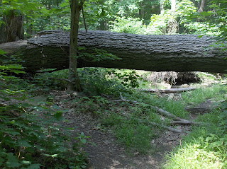
I finally found the perfect picture to demonstrate a f*ck-it path. There was this huge tree down over the trail and a small rockfall in front of it. The original trail actual heads off to the right in the picture, and (at this point) several enterprising souls have blazed a new path around the obstacle as you can see to the left in the picture. This was actually taken from the back side.

A little further on down the trail, I hit Ruckman's Point. This is a gorgeous lookout over the Hudson and lots of very old graffiti. The oldest one I could make out was 117 years old!


Before you get to the really evil climb down the cliffs portion of this hike, the trail runs by this Rapunzel looking tower thing. This is actually a monument to the the Women's Federation. The Federation was comprised of several women's groups who fought to keep the Palisades safe from quarrying eventually convincing New York Governor Teddy Roosevelt and New Jersey Governor Foster Vorhees to establish the Palisades Interstate Park Commission and designate this area protected land. I find it kind funny that a monument to women looks a bit like a prison.


There were several hikers and DHPs taking a break in the little garden that surrounded the is monument so I took a break as well to replenish my small bottle of water and munch on a granola bar.

Then I headed off to face the pain. The strenuous down portion of the hike. The trail descends first on a series of steep stone steps built in the early twentieth century, so they are not in the best repair and then it continues down on short. steep, rocky switchbacks, more fit for a billy goat than and middle aged woman with bad knees. . The steps were so steep I was starting to get a little vertigo, I stayed well back from the edge and sidled down the steps more than I walked down them. It's only three tenths of a mile, but it feels a lot longer when your taking your time to make sure you have your footing.

It's a relief when you finally hit the Shore Path down below. This part of the hike offers a nice respite. And even better, when there is a big boulder fall off to the right of the path, the breeze that comes off the river gets cooled and bounced back at you. It's like a natural air conditioning. And believe me I needed it. I was sweating like Dick Cheney at confessional. I was pretty much soaked through at this point, the only dry area of my tank top was the bottom hem. While I enjoyed the less strenuous stroll, not having to concentrate on where I was putting my feet, made me pay attention to the fact that my feet were getting really tired and soar. But knowing I was more than half way done, kept me moving forward. I took an alternative path a little way along, that gave me a little up and went through more of a wooded area. But I knew that the pain was coming.

Soon I reached the Closter Dock Trail. This is was my up point, back to the top of the cliffs. This trail is an old cobblestone road, once used by the British Troops during the revolution, when they tried to intercept Washington on his way to Trenton. Do you know what happens to cobblestone roads after a couple hundred years? The cobblestones shift and move and upend. It's kind of a pain to walk over them. And dangerous to your ankles. This trail ascends on a a series of long switchbacks. It really takes it out of you. I find it works best to keep my head down, walk slowly and count my steps. If see how much farther it is too the top, it can get discouraging. And at this point it's only six tenths of a mile back to the parking lot. I was ready to finish.

I finally trudged my way back to the car in a little under 3 hours. My trusty pedometer read:

5.96 miles
13988 steps
626 calories burned (at least!)

Oh, and I have to mention, that while I was sore, my right knee was much happier after this hike since I gave it the same kind of support I give to my left knee. Hooray!

The next two weekends I won't be able to hike. Next weekend, I'll be walking around St. John, New Brunswick, Canada while on my Victory Cruise. And the weekend after that, my best friend, My Brian, is coming into to town from Indiana to visit. I can't wait to see him!

Cheerios!

Sunday, June 22, 2008

Day 22: Catching Up...

First, I apologize for not blogging on either Friday or Saturday. This had been a off week. Off in many ways. A high, high with the birth of my nephew, a lovely evening with Kevin, but a lot more lows with a bad mood, work stress, and some poor eating choices, and an inability to muster any enthusiasm for exercise this week. I mean I didn't sit down and eat a whole box of Entenmann's Rich Frosted Donuts or a pint of Ben & Jerry's or even a package of Funny Bones (all though I had a close call with that last one). And I did actually exercise most days this week. But I didn't try very hard. And today I broke down and had a small chocolate soft ice cream cone from Mr. Softee.

Interestingly enough the hike that I took yesterday basically reflected the way my week has gone. Some really great and beautiful highs (literally) and some really low lows (mentally).

This week's hike was in Ringwood State Park. The write up says that it is a 5.5 mile hike. They lied. And I must take this moment to apologize to my brother Chris. I dragged him on this hike the year before last telling him that it was only a 5.5 mile moderate hike. He could do it. Well, he decided to wear his brand new pedometer and by the time we dragged our carcasses back to the car his pedometer read 6.2 miles. I told him that he must have configured his pedometer wrong or that it wasn't working properly, because the write up clearly says that it is a 5.5 mile hike. Well, when I got back to my car today, my pedometer read... 6.2 miles. Sorry I doubted you Chris!

Anyway, this hike has three significant ups in it and they all happen in the first half of the hike. As a matter of fact, the first one, the trek up Cupsaw Mountain, happens in the first half mile. This one starts you off with a very picturesque walk over a couple of wooden bridges, but once you cross the road, the pain starts. It's an immediate uphill trudge, no getting the muscles warm, just straight into it. Fortunately, it's not a very long up, it's a little steep in places, but not too bad. I even saw a deer leaping across the trail above me on the the mountain. Once up to the ridge, you have to go back down.

Oddly enough, I dread steep downs more than I do steep ups. Downs are a lot harder on my knees. I have to take them really slowly and make sure that I place my feet carefully with each step. Remember when you were a kid, how you could just run full speed down a hill and if you fell down it was fun and you just rolled the rest of the way down the hill? Yeah, me too. But these days, not so much.

The trail lead down into a wet area. There were quite a few spots of "seasonal wetness", some real shoe sucking mud. But soon I came out into the Shepherd Lake Recreation Area. There were lots of people already there (around 10:30 in the morning), swimming in the lake, fishing, renting kayaks and boats. I was already sweating like George W. Bush at a spelling bee, so it was very tempting to kick off my boots and just walk into the lake. But the prospect of walking another 4 miles or so in wet underwear and shorts kept me on the shore. I had a nice stroll along side the lake, and then turned off the road and began the trek up the second serious up.

I know I started this hike pretty early, but I didn't see a single other soul on the trails. Not a one. Not a single DHP, not a single unprepared day hiker. Maybe they knew something that I didn't know.

The third significant up is the hike up Mount Defiance. This is where you get the really money shots. It's also where the ups get steeper and the downs get scarier and it requires a bit of rock scrambling. Oddly enough, you don't get the views from the peak of the mountain. It's more like a rocky meadow up there, but then you head down a bit and the trail parallels some "impressive cliffs". The only problem is that you actually have to climb down to parallel those impressive cliffs. It was a bit of a scramble and I think I hyperextended my right knee during it. That knee started giving me problems over the rest of the hike.

I think my knees have a bit of a sibling rivalry going on. I've mentioned before that I had surgery on my left knee, so I tend to favor the left. The right knee has become aware of this and is rebelling. The left knee gets to wear the knee brace with the metal hinges, while the right gets the basic neoprene support. Apparently the right knee has become jealous of the support I give the left and let me know it by aching badly for the rest of the hike and being stiff all day Sunday. So I went out and bought the right its own "bionic" knee brace today.

Back to the hike. As I came down the trail there were a couple of side trails that I followed to rock out croppings with a fabulous view over the surrounding area. It was absolutely gorgeous, so lush and green. I would have loved to stay longer, but was starting to get really tired and my knees and feet were starting to ache so I made my way down the mountain on a switch back trail. I eventually came out on the grounds of Skylands Manor. It's a lovely area with a Botanical Garden, but I was too tired to explore it.

Now, occasionally on a hike you hit a point where you are just done with the hike. You may not actually be at the end of the hike, but your body and your mind are done with it. Your feet hurt, your knees aches, the charm of nature has worn off and all you really want to do is get back to your car and turn on the air conditioning. I was done with this hike almost two miles from the end. I was tired of the bugs buzzing in my ear, I was tired of the face fulls of webs I kept getting. I was tired of picking my way through muddy areas, I was tired of bushwhacking my way through lesser used areas of the trail. I was tired. And I was done. But, I had to slog through that last two miles to get to my car and its air conditioner. I was never so happy to see a hike end. But then of course I had to walk to the bathroom across a field and back and that added another 1/10th of a mile to the hike.

When I got back to my car my trusty pedometer read:

Miles: 6.35
Steps: 14905
Calories burned: 705
In a little over 3 hours.

Today I woke up grumpy and sore. We did diner breakfast and then I went for a little retail therapy. But walking around the mall made my feet sore and my knee hurt. So fat lot of good that did me.

I think I'll go to bed now. Tomorrow will hopefully be better.

Sunday, June 15, 2008

Day 15: Baiting the Wolverines and A New Magic Number

Today's magic number is...

2.8

I lost 2.8 pounds this week. That brings the total to 7.1 pounds so far. Now just for kicks when I got back from my hike today I weighed myself again, and I was almost a pound lighter. But that had to be water weight since I sweated like George W. Bush strapped to a lie detector. So we will stick with the morning's number.

That puts me at 205.6. I tell ya, when I get under 200 I'm gonna party like it's 1999! Oh wait, I was over 200 in 1999. So I guess I'm gonna party like it's 1994!

So today's hike was Pyramid Mountain in Montville, New Jersey. The write up says it was a 4.5 mile moderate loop hike, however, since they have re-routed a number of trails it's actually about 5 miles now (4.97 miles to be exact). It's shorter than my last 2 but it has more ups and the ups are more intense and rocky as are the downs (there was butt sliding involved).

I've done this hike several times in the past. And, by the way, this is one of two hikes that I've actually spotted a bear on. It starts out with a lovely little walk in the woods. But once you get on the yellow blazed trail the pain starts. Half the time you are looking for the next blaze and you lookup and see it over a big pile of rocks and boulders. But for the blazes, the trail isn't always clear.

My pedometer refused to count aerobic steps for me today. It is resolutely saying 0 aerobic steps taken, but with the way my heart was pounding and the fact that I was breathing as heavy as an obscene phone caller, at several points along the trail, says that I did indeed take many aerobic steps in the course of my journey.

The many ups on the trail provided a little rock scrambling for me which I enjoy. However, we had some big storms come through here last night and every thing was damp which makes the moss and lichen covered rocks a bit slippery. There were many moments on the trail today that I was thankful for my hiking stick and good hiking boots with ankle support.

The other things that the many ups give you is some really nice vistas. They are the reward for getting your ass up the mountain.


I saw lots of people on the main trails that I used today. A lot families out together. And not a single DHP! Probably because many of the trails are too darn rocky for safe running.

The main features of this trail are what is called "glacial erratics". Glacial erratics are boulders left behind in curious positions by the movement of the glaciers through this area many millions of years ago. The most curious of these erratics is Tripod Rock. This is an enormous boulder balanced on three smaller boulders. There are also two other smaller rocks sort of similarly situated nearby. The interesting thing about the two small boulders is that they form a perfect "gunsight" for a summer solstice sunset.


When I arrived here today there was a group of kids and adults climbing around, over and under the rocks taking pictures. The kids looked like they were really enjoying their time outdoors which was really nice to see in this age of couch potato kids. Having been through here any number of times, I suggested a couple of other picture options, that are kind of fun photo tricks. These pictures are from a couple years ago...


After this the trail descends into a swampy area. The 3 signs you are in a swamp in New Jersey, skunk cabbage, fiddle ferns and dead bodies. Wait, I'm just kidding about that last one. The third sign is the mosquitos. I don't have pictures from this area, because if you stop for a moment you get swarmed. So I kept moving to head for the higher elevations. The other big glacial erractic I encountered just before I left the swamp was Bear Rock. The hike description says Native Americans used to shelter by this ginormous rock. It's pretty impressive looking.


As I approached the end of my hike, I met a lot more people coming up the trail. It seems there was a party in a park nearby and some of the party goers decided to take a stroll in the woods. I met one such couple and their young daughter at the top of the highest point in the park. They had decided to follow the blue trail and had no idea where it would take them. The father had a beer in his hand and the wife had a small bottle of water. At least they had sense enough to ask me where the blue trail led (out of the park and into another county!) and how to get back to the parking area, without having to go back the way they came. I pulled out the map I had picked up and showed them where they were and that they should make a right onto the yellow trail when they came to the junction. and that would lead them back to the parking area. Then, I gave them my map and they set off down the trail. I just shook my head as I started back down the trail. Maybe I'm just anal, but I can't fathom wandering off in the woods without at least a trail description or better yet a map and a sufficient amount of water.

I passed several more groups heading up the mountain without maps or water. Pyramid Mountain is a pretty well traveled trail area, so I'm sure they made it out fine. But to me they just looked like wolverine bait.

By the time I made it back to my car, my trusty but temperamental pedometer read:

Miles: 4.97
Steps: 11670
Aerobic Steps: 0 (bull dookie!)
Calories burned: 531 (at least!)
Time: about 2 hours 45 minutes
I was soaking wet and looking forward to nice long shower when I got home.

Why is it that even when it's hot and humid out and you are disgustingly hot and sweaty, a hot shower still feels so good?

Oh, a quick note about Saturday. My cheat day so we did diner breakfast. I ran a bunch of errands and then that evening it poured. So exercise for the day was the treadmill. I'm attempting the Couch-to-5K Running Plan that one of John Heald's Bloggers mentioned. I think I did pretty well for the first time. But it was tough and I was dripping with sweat when I finished. I decided to follow it up with some light weight work, since one of my doctors once told me "I don't care what you weigh, as long as you build muscle." Because muscle metabolizes sugar better and faster.

I'm off to watch the Tonys. 'Night all!

Sunday, June 1, 2008

Day 1... Off To An Okay Start


This is me two weeks ago at Disney World. I'm the one in the tiara. This is the starting point. I have to admit I'm a little ashamed to post the following starting figures, but it's only fair, so ya'll will be able to see the changes.

But here we go:

Height: 5'7" (I was 5'6" for a very long time and then a couple of years ago the doctor told me I was 5'7"! Go figure!

Starting weight: 212.7 pound (Egads! Still it used to be worse!)

BMI: 33.3 (yes, this puts me into the obese category. That hurts!)

Bust: 45" Thigh: 25.25"
Waist: 39.5" Upper Arm: 16"
Hips: 45"

Today's exercise: Hiking

I woke up this morning, knowing that it was D-day. so I got up and instead of running for bagels, I had oatmeal with sliced strawberries and a little 2% milk. It was an absolutely gorgeous day out so I planned to go hiking after I dropped my boyfriend off at work.

There are tons of places to hike in the Northern New Jersey / New York area. I chose to do one that I had done before, South Mountain Reservation in Millburn, New Jersey. It's a 6 mile moderate loop hike in the Watchung Mountains. This hike has two big pluses. First, it's only about 30 minutes from my house. Second, the most difficult parts of the trail are in the first 3.5 miles, so the last 2.5 miles, feels like a nice stroll in the woods. The one big minus is that the first half mile is ALL up.

Now lest y'all think I'm being too ambitious with a hike like this, I should explain that I'm not a novice hiker. I've been day hiking for several years, just not as often as I would like or would help. One spring and summer a friend and I managed to hike almost every single weekend from April to November, just missing a couple. I got in decent shape, but of course, I was eating crap, so I didn't lose a whole lot of weight.

Anyway, this being the first hike I'm telling you about, I should probably explain a few other things. Now, you know when you see a commercial with that outdoorsy type couple hiking through the woods and she's wearing cute little khaki shorts and cute, clean hiking boots and a tank top, lightly leaping from stone to stone across a stream, with nary a bead of perspiration marring her brow? That is SO not me. I look like I'm heading out to war. I wear a t-shirt, cargo shorts (with a big pocket on the side for a water bottle), a baseball hat to keep the sweat from running into my eyes (because I sweat, a LOT) and keep the creepy crawlies out of my hair, hiking boots that are scuffed and muddy, knee braces on both knees, and a hunter orange backpack, with emergency first aid kit, ponchos, an emergency blanket, bug spray, sun block, and at least 3 liters of water.

The hunter orange backpack was purchased after one hike during October when we discovered we were out in the woods in green shorts and a brown t-shirt on the Opening Day of hunting season. Live and learn people!

I also use a hiking stick. I have terrible knees because of years of being overweight. The hiking stick is a godsend. It has kept me from falling flat on my face when tripping over roots and rocks. It helps me balance on stones and logs when crossing streams or swampy areas. And it gives me that little extra support when scrambling up and down rocks. My friend borrowed one of mine once and the very next week she had her own brand new stick. They are just that helpful.

There are a few hiking terms you may need to know as well.

  1. DHP's (Damn Healthy People) These are those people that coming running along the trail right past you in their little running outfits and sneakers. They seem to magically fly over the stones and roots that threaten my knees and ankles with egregious injury with every step I take. And even though that level of fitness is something to aspire to, when you're sweating your way up a 45% incline stopping to catch your breath, sometime you just want to stick your foot out and trip them.
  2. Seasonal Wetness When a hike description mentions that you may encounter "seasonal wetness" that could mean anything from a couple of puddles on your path, to big mud pits that threaten to suck down your whole leg if you fall off of the log or stepping stones, some kind soul before you had laid over it, to gushing streams of water crossing the path in front of you. My favorite was the seasonal wetness that washed away the small foot bridge and sinking the boards in the mud so you had to solve the puzzle of where to put your feet to get across.
  3. F*ck-it Path When you encounter an obstacle in your path, it could be the aforementioned seasonal wetness, a fallen tree or a boulder and your legs feel like lead already, look to the left or right. Chances are someone has been there before you, looked at the obstacle and said, "F*ck it." And blazed a new trail around the obstacle.
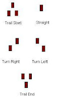
  4. Blazes These are the markers that you follow down the trail. They are usually rectangles painted on the trees and boulders, or colored metal discs or rectangles nailed to the tree. The color tells you which trail and the positioning tells you which way to go. Fortunately, trails that are maintained by the New York/New Jersey Trail conference are pretty well blazed and maintained. But still sometimes you really have to look for the next one (trees do fall after all).
  5. Unnecessary Ups These are the bane of my existence. An unnecessary up often occurs when you miss a blaze and make a wrong turn, happily thinking that thank goodness it's downhill, only to realize when you get to the bottom that you went the completely wrong way and now you have to climb back up. That climb is an unnecessary up.
This is getting kind of long and I haven't even talked about the actual hike! Well, like I said, it is a 6 mile hike and it starts from a parking lot where you pick up the yellow-blazed Lenape trail. Of course all excited for my hike and thinking I remembered where to go, I headed off through the picnic area and promptly missed the next blaze and ended up in someone's backyard. Ooops.

The first half mile is walking up the mountain. It's not terribly, steep but it is significant and I had to stop often, taking it in small sections of 30 steps at a time. And of course it was here that I ran into the only DHP I encountered, but he was running downhill, so I felt better. I finally reached the top and was greeted with a grand view of the valley below me and the NYC skyline to the East. Up here there are a bunch of Revolutionary War Monuments because George Washington apparently stood here at some point and surveyed the approach of the Redcoats below. I've seen all this before so I soldiered on.

I wish I had pictures to post, but my boyfriend left the camera at his office...

After that the trail gets more rugged, moving up and down and it goes around the mountain. I crossed a couple of cascades that because of rain the night before had a decent amount of water running over them. I kept glancing at my pedometer thinking am I halfway yet? Nope. I was in a more remote section of the park at this point. I didn't encounter anyone for a very long time. It can be a little eerie when you're hiking by yourself.

After almost 3.5 miles I finally hit the landmark of this hike. A decent sized waterfall, complete with a shallow pool and today, two little nymphos, I mean nymphs, in white bikinis taking pictures of each other standing under the cascade, photos which will probably end up on their myspace page. Yeah, that's what I needed to see. I was hot, sweaty, I had ripped my shorts up the side, I was filthy, and not to mention 60 pounds overweight. Well, somebody up there has a sense of humor. Thanks. But I sat down a little ways away and ate my 100 calorie no-sugar added granola bar.

After the falls it was on to the white blazed Rahway trail, which follows along the Rahway River. It's a pretty easy walk after that. I encountered lots of people strolling along the easier and wider bridal trails to got visit the falls. I met one group of women on the actual trail who asked me directions to the falls. One of the women said, "We were just admiring your knee braces." I said, "I learned a long time ago. They're not sexy, but they work!"

The last mile and a half went quickly. I was happy to see the glint off of the cars in the distance. By the time I reached my car, according to my pedometer, I had walked 5.88 miles, taken 13298 steps, 9803 were "aerobic" steps (however, pedometers base on time and steps, they don't take into account inclines), and burned at least 594 calories (again only factors based on walking level), in 3 hours. I was tired.

Whenever I get off a trail the first thing I do is call my boyfriend and tell him that I "didn't get eaten by wolverines." This is a little running joke between us, after he warned me one time not to get eaten by the wolverines. Occasionally when I call after a hike, he'll answer, "Wolverine hotline!".

By the time I got home all I wanted was a shower and a sit down. Why do hot showers feel so much better when you are sweaty? When Scott got home from work, we decided to go out to eat. Ah a test of the diet! We went to a Mexican place, Charritos, I got their grilled chicken fajitas, figuring that was the safest option. And I left the sour cream alone! But not the guacamole. I love guacamole....

I ignored the kitchen after 8 pm. Tried to concentrate on everything but food, before finally going to bed.

All in all, I'd say it was a pretty successful first day. Oh lord, how many more days of this?